

In a landmark move aimed at correcting centuries-old geographical distortions, the United Nations General Assembly has voted overwhelmingly to replace the traditional Mercator world map with a projection that more accurately represents the true size of Africa and other continents.
The resolution, known as “Correct the Map,” was sponsored by Togo and supported by member states of the African Union. It received backing from 164 countries, including major global powers such as France and the United Kingdom.
The United States emerged as the lone country to vote against the measure, while six nations chose to abstain.
Although the resolution is not legally binding, its adoption is expected to influence the maps used by international organisations, educational institutions, publishers and governments worldwide.
For decades, critics have argued that the Mercator projection, one of the world's most widely used maps, presents a misleading picture of the planet by dramatically enlarging regions closer to the poles while shrinking countries and continents near the equator.
One of the most cited examples is Africa, which appears on the Mercator map to be roughly comparable in size to Greenland. In reality, Africa is about 14 times larger.
Supporters of the resolution say such distortions are not merely technical flaws but have helped shape global perceptions that underestimate the continent's vast territory, population, resources and economic potential.
The Mercator projection was developed in 1569 by Flemish cartographer Gerardus Mercator to assist European sailors with navigation. While it proved highly useful for plotting sea routes, experts note that accurately translating the Earth's curved surface onto a flat map inevitably creates distortions.
As a result, countries closer to the equator appear smaller than they actually are, while those near the Arctic and Antarctic regions seem disproportionately large.
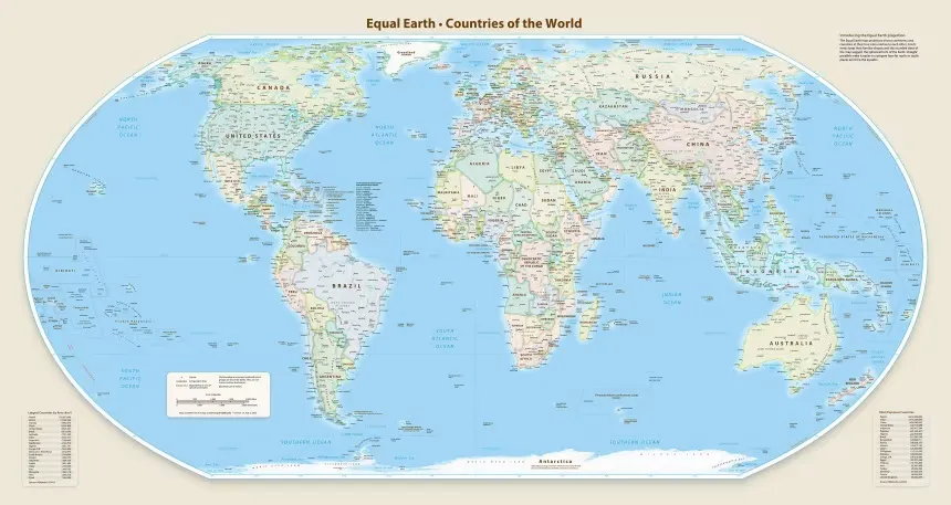
Seeking a more balanced representation of the world, cartographers introduced the Equal Earth projection in 2018. The alternative map was specifically designed to preserve the relative sizes of continents and countries more accurately.
Momentum for change gained traction earlier this year when the African Union's 54 member states formally adopted the Equal Earth projection, arguing that it provides a fairer representation of the world's geography, particularly Africa.
The campaign has also attracted support from advocacy groups seeking to challenge long-standing misconceptions about the continent. The online movement #CorrectTheMap has frequently highlighted Africa's immense scale, noting that the United States, China, India, Japan, Mexico and much of Europe could fit within Africa's borders and still leave significant land area remaining.
Ahead of the UN vote, Togo's Foreign Minister, Robert Dussey, framed the issue as one of fairness and representation.
“A fair world begins with a fair map,” he said.
Addressing delegates at a UN briefing, Dussey argued that maps play a powerful role in shaping global understanding.

“A map is never neutral. It shapes perceptions and influences how the place of peoples and continents in the world is understood,” he stated.
France strongly supported the initiative, with Foreign Minister Jean-Noël Barrot announcing that his country would discontinue the use of the Mercator projection.
“Changing the map obviously doesn't change the world. But correcting a representation that distorts it is already an act of truth,” Barrot said.
The United States, however, dismissed the proposal as a misplaced priority.
Speaking during the debate, U.S. representative Yaryna Ferencevych criticised the resolution, arguing that the General Assembly should focus on pressing global challenges rather than centuries-old cartographic issues.
“Instead of focusing on genuine problems of international peace, prosperity, or good relations, this body is debating map projections from the 16th Century and their role in promoting reparations and cognitive justice,” she said.
The vote comes months after Washington also opposed a UN resolution that described the transatlantic slave trade as “the gravest crime against humanity.”
Advocates of the new map insist that the issue goes beyond geography.
Lerato Mogoatlhe of Africa No Filter, one of the organisations campaigning against the Mercator projection, said the inaccurate portrayal of Africa has contributed to misleading narratives about the continent for generations.
“Africa's misrepresentation on world maps is not just a cartographic error — it's a narrative issue,” she said.
According to Mogoatlhe, the campaign is part of a broader effort to challenge what she described as one of the world's longest-running forms of misinformation about Africa.
Kenyan geographer Kioko Muendo echoed that view, arguing that the way maps portray countries can influence political, economic and investment perceptions.
“Maps are more than just guides for travellers,” he said. “They shape how regions are perceived politically and economically.”
For supporters of the resolution, the UN vote marks more than a technical adjustment to map-making. It represents a symbolic step toward ensuring that Africa's true scale, significance and global standing are reflected more accurately in how the world sees itself.


Comments (0)
No comments yet. Be the first to share your thoughts!